Nov 2021 (4 weeks)
Directionally Diverse
Ever found yourself second-guessing directions in a busy transit station? This project examined how social context, language and gender shapes navigation behavior, informing a new model for digitally assisted wayfinding in collaboration with BMRCL.
Wayfinding
Participatory Research
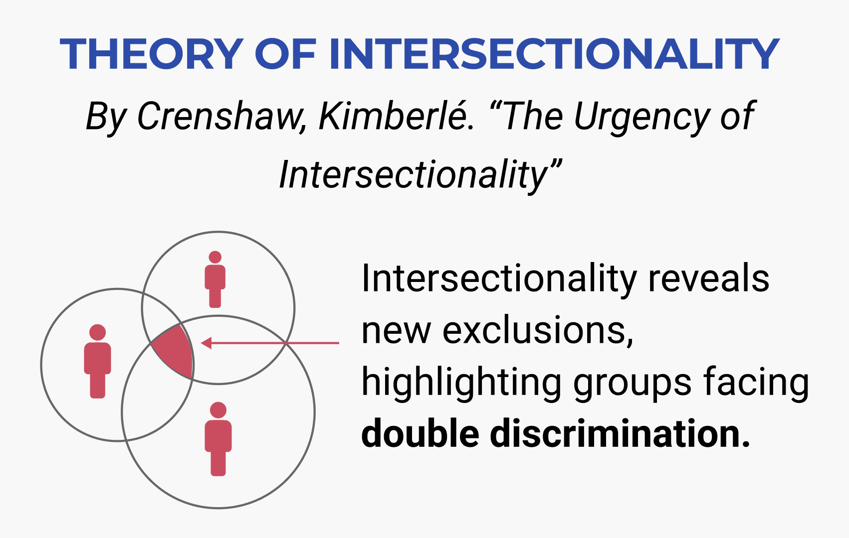
Intersectionality
Ever found yourself second-guessing directions in a busy transit station? This project examined how social context, language and gender shapes navigation behavior, informing a new model for digitally assisted wayfinding in collaboration with BMRCL.
Nov 2021 (4 weeks)
Directionally Diverse
Ever found yourself second-guessing directions in a busy transit station? This project examined how social context, language and gender shapes navigation behavior, informing a new model for digitally assisted wayfinding in collaboration with BMRCL.
Wayfinding
Participatory Research
Intersectionality
Ever found yourself second-guessing directions in a busy transit station? This project examined how social context, language and gender shapes navigation behavior, informing a new model for digitally assisted wayfinding in collaboration with BMRCL.

Role
Role
Individual Contributor
Individual Contributor
Industry Sponsor
Industry Sponsor

Bangalore Metro Rail Corporation Ltd
Bangalore Metro Rail Corporation Ltd
The Problem
The Problem
75% of daily commuters are lost while navigating Majestic Metro Station, Bangalore
75% of daily commuters are lost while navigating Majestic Metro Station, Bangalore

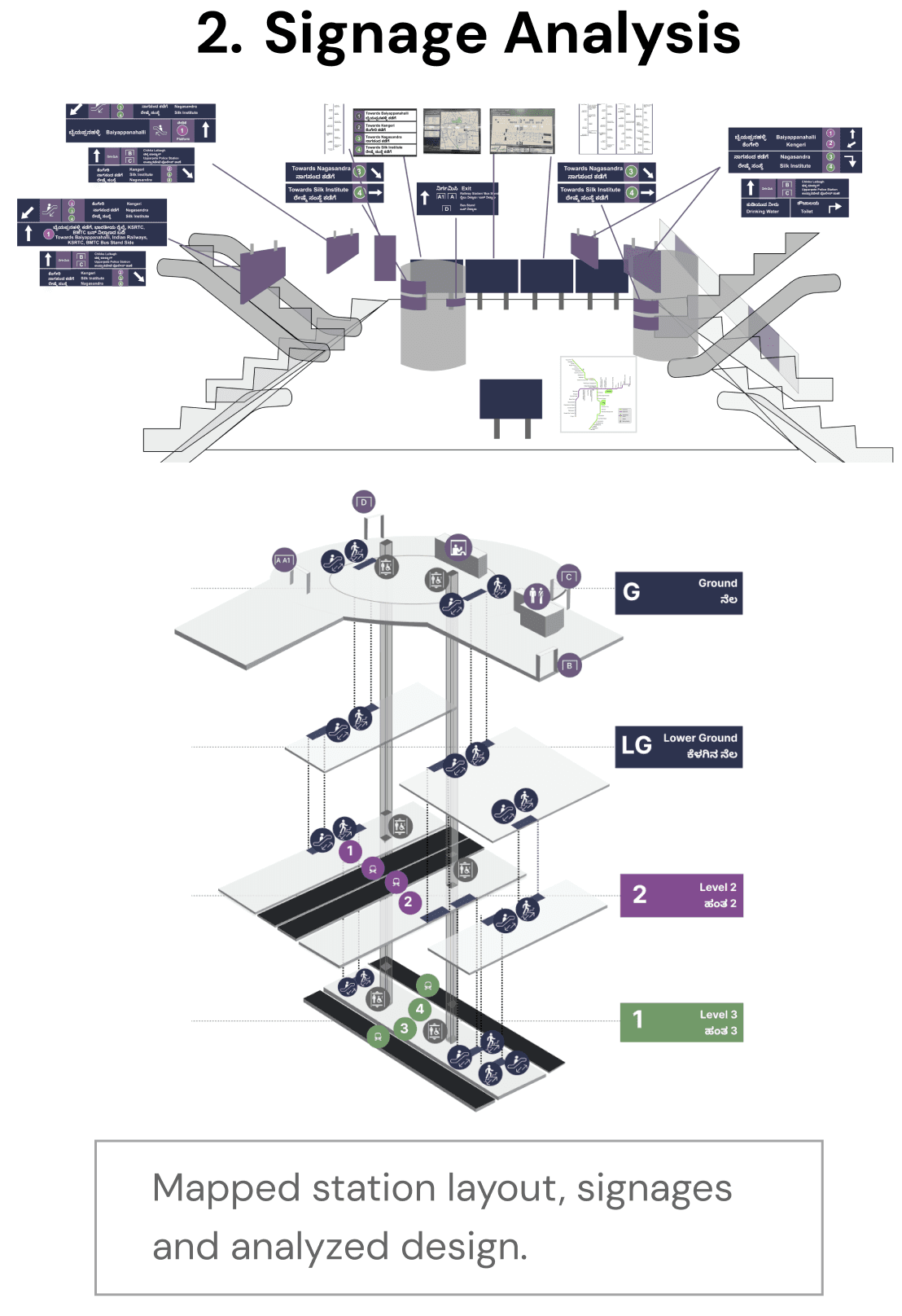
Breaking down the probelm
Breaking down the probelm
But what makes the station hard to navigate?
1.Extremely Crowded
1.Extremely Crowded
City population: 14 million
City population: 14 million
Daily ridership: 900,000 approx
Daily ridership: 900,000 approx
2.Signs That Don’t Work
2.Signs That Don’t Work
Unclear signages
Unclear signages
Poor signage placement
Poor signage placement
3.Language Barriers
3.Language Barriers
105 local languages spoken
105 local languages spoken
42.12% migrant population
42.12% migrant population
Communication is a challenge due to the limited use of universally understood languages like Hindi and English.
Communication is a challenge due to the limited use of universally understood languages like Hindi and English.
4.Complex Station Layout
4.Complex Station Layout
Interchange hub
Interchange hub
3-level underground
3-level underground
.Connects 2 metro lines, railways and intercity buses
.Connects 2 metro lines, railways and intercity buses
(The Design Process)
User Research
Engaged with commuters and the space to identify Design Opportunities
Why are the signs not understood?


What are the navigation patterns of commuters?


How do commuters experience the space?


Key Insight
Key Insight
The issue isn't just poor signage or layout— it’s deeply tied to Social Dynamics.
The issue isn't just poor signage or layout— it’s deeply tied to Social Dynamics.


(Solutioning)
Why don’t existing navigation systems work in this scenario?
Why don’t existing navigation systems work in this scenario?
Understanding gaps in GPS, signage, and AR — across both physical and digital navigation.
1. Signage
1. Signage
Static and location-bound, cannot be accessed anytime or carried for reference.
Static and location-bound, cannot be accessed anytime or carried for reference.
2. GPS (google maps)
2. GPS (google maps)
Lacks visual clarity, leaving room for misinterpretation. Portable but not intuitive for physical space association.
Lacks visual clarity, leaving room for misinterpretation. Portable but not intuitive for physical space association.
3. AR Navigation
AR requires high tech requirements, not all users have compatible devices, plus it demands high attention and focus.
(Solution 1)
A Gallery-like Navigation
Design Challenge 1
Design Challenge 1
I want a solution that doesn’t require reading.
I want a solution that lets me navigate quickly with minimal attention and is always accessible.
I want a solution that works on all devices.
I want a solution that doesn’t require reading.
I want a solution that doesn’t require reading.
I want a solution that lets me navigate quickly with minimal attention and is always accessible.
I want a solution that lets me navigate quickly with minimal attention and is always accessible.
I want a solution that works on all devices.
I want a solution that works on all devices.

A simple, clear new navigation method that uses a series of easy-to-follow images
A simple, clear new navigation method that uses a series of easy-to-follow images

(Solution 2)
Digital cues aligned with physical space
Design Challenge 2
Design Challenge 2
I want a solution that doesn’t require learning or understanding new systems.
I want a solution that doesn’t require learning or understanding new systems.
I want a solution that doesn’t require learning or understanding new systems.

(Solution 3)
Location Identification
Design Challenge 3
Design Challenge 3
I want a solution that doesn’t require learning or understanding new systems.
I want a solution that helps me quickly identify my exact location when I’m lost.
I want a solution that helps me quickly identify my exact location when I’m lost.


Recap
Overcoming Information Overload: Traditional signage often overwhelms users with too much information, making it hard to read, remember, and act on while navigating. Image-based navigation simplifies this by providing concise visuals of routes, stored directly on users' devices. These images allow quick and intuitive associations with the surroundings.
Reducing Network Dependency: Unlike GPS or AR navigation, which rely on strong networks, image-based navigation works with minimal connectivity. At Majestic Station, the existing network is sufficient to download images, ensuring reliable performance without requiring advanced infrastructure.
Fun fact: Tested with Zomato's app, which handles thousands of restaurant images flawlessly—proving the concept works even in resource-heavy scenarios! 🍔📸
Impact
Received positively by the Spatial Design Team and BMRCL, with approval to build a digital system (pilot at Majestic Metro Station). Findings and test results for my project served as the starting point
Received positively by the Spatial Design Team and BMRCL, with approval to build a digital system (pilot at Majestic Metro Station). Findings and test results for my project served as the starting point
Received positively by the Spatial Design Team and BMRCL, with approval to build a digital system (pilot at Majestic Metro Station). Findings and test results for my project served as the starting point

Project was featured at TU Delft’s Spatial Justice Symposium (Center for the Just City) through both the conference and journal.
Project was featured at TU Delft’s Spatial Justice Symposium (Center for the Just City) through both the conference and journal.

I was invited to present at ITD24 Netherlands, my project was recognized for its impactful use of interdisciplinary methods. Know more here
I was invited to present at ITD24 Netherlands, my project was recognized for its impactful use of interdisciplinary methods. Know more here

Intresed in knowing more about my detailed research and insights?
Intresed in knowing more about my detailed research and insights?
Intresed in knowing more about my detailed research and insights?
Integrated methodologies from wayfinding studies (interdisciplinary approach) and intersectionality theory (transdisciplinary, rooted in sociology).